


Dr. Shu-Ching Chen is the inaugural Executive Director of Data Science and Analytics Innovation Center (dSAIC). dSAIC is a multi-university center and based at the University of Missouri-Kansas City (UMKC). He received his Ph.D. degree in Electrical and Computer Engineering in 1998, and Master's degrees in Computer Science, Electrical Engineering, and Civil Engineering in 1992, 1995, and 1996, respectively, all from Purdue University, West Lafayette, IN, USA.
Projects
Dr. Chen has worked with undergraduate and graduate students on the design, implementation, and maintenance of challenging, far-reaching, and community-centered projects.
Florida Public Hurricane Loss Model
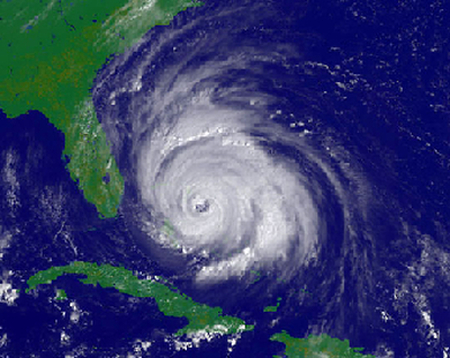
Dr. Chen is the leader of the Computer Science Component of the Florida Public Hurricane Loss Model (FPHLM), a large-scale hurricane catastrophe model developed by a multi-disciplinary team of experts in the fields of meteorology, wind and structural engineering, computer science, GIS, statistics, finance, and actuarial science. It is the first public hurricane loss model in the world. The realization of this innovative project involves the close collaboration of multiple academic and scientific institutions, of which Florida International University is the leading institution.
The state of Florida ranks number one in total insured property value exposed to hurricane wind. Out of Florida's $3.6 trillion in insured properties, about $2 trillion are residential, and all are exposed to hurricane risk. This reality gave birth to this project. Funded by the Florida Office of Insurance Regulation (FL OIR), the FPHLM was born out of the need of accurately assessing hurricane wind risk and predicting insured losses for the Floridians' residential properties. Since the release of its first version in March of 2006 (see press release), the model has been used over 3,600 times by the state and over 280 times by firms in the insurance industry. As an open project, which undergoes a strict certification process every two years, the FPHLM provides the state regulators a reliable benchmark in the homeowner insurance market and allows them to better formulate the state's homeowner insurance rate-making policy. The FPHLM's impact on the community is unquestionable, as its predictions directly influence the home insurance rates payed by Floridians every month.
The model consists of three major components: wind hazard (meteorology), vulnerability (engineering), and insured loss cost (actuarial). It has over a dozen sub-components. The computer platform is designed to accommodate future hookups of additional sub-components or enhancements.
The FPHLM estimates loss costs and probable maximum loss levels from hurricane events for personal lines and commercial lines of residential property. The losses are estimated for building, appurtenant structures, contents, and additional living expenses.
In essence, the FPHLM is a complex collection of computer programs that simulate and predict how, where and when hurricanes form, their wind speeds, intensity and sizes, their tracks, how they are affected by the terrain after landfall, how the winds interact with different types of structures, how much damage they can cause to house roofs, windows, doors, and interiors, how much it will cost to rebuild the damaged parts, and how much of the loss will be paid by insurers.
Florida also ranks number one in coastal property exposed to storm surge. In the face of this reality, in 2013 the state funded FIU to enhance the FPHLM by adding both a storm surge component and an inland flooding component. The proposed new model will assess storm surge and hurricane-related rain flood risk and estimate both the insured and uninsured losses that they may cause. The enhancement project will take three years with $4.5 million funding from the State.
More information on the FPHLM is available on the project's web site.
Miami Herald - Florida property insurers get high marks in hurricane 'stress test' - We ran the FPHLM model for FL-OIR in Summer 2015.
Storm Surge Simulator
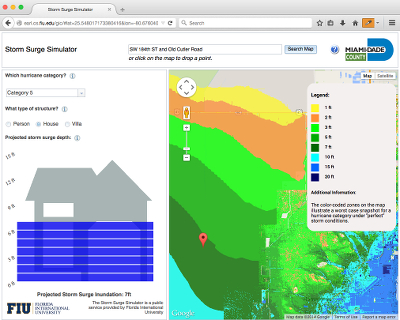
Miami-Dade County is particularly susceptible to storm surges caused by hurricanes. To help Miami-Dade county residents understand the dangers of storm surge, hydrological and software development experts at FIU's International Hurricane Research Center (IHRC) and College of Engineering and Computing (CEC) teamed up with Miami-Dade County to create a Storm Surge Simulator, a web-based application that allows users to visualize the potential storm surge effects on their home or business.
Dr. Chen led the development team of Computer Science students to combine cutting-edge web technologies with storm surge modeling output in order to help the Miami-Dade community.
The result of the paper A Progressive Morphological Filter for Removing Non-Ground Measurements from Airborne LIDAR Data, authored by Dr. Chen and his colleagues K. Zhang, D. Whitman, M.-L. Shyu, J. Yan, and C. Zhang, and published in IEEE Transactions on Geoscience and Remote Sensing, vol. 41, issue 4, pp. 872-882, April 2003, was used by the official Miami-Dade County Storm Surge Simulator project. This paper has been cited 1177 times by Google Scholar.
The Storm Surge Simulator has been reported by many media outlets including the Miami Herald, the Florida Statesman, Mapperz - The Mapping News Blog, the AnyGeo Blog, the MapThis! Blog, Google Maps Mania, WIOD 610AM, Diario Las Americas, NBC 6, CBS 4, the Emergency Management Magazine, and the Government Technology Magazine.
The Storm Surge Simulator is available to the public at no charge. Click here to visit the Storm Surge Simulator.
3D Hurricane Storm Surge Animation and Visualization
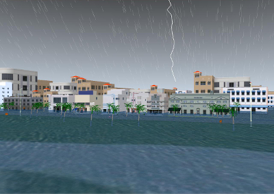
Dr. Chen's work on 3D Hurricane Storm Surge animation has been used by NOAA's National Weather Service (NWS) Tampa Bay Area Office. Demo videos of the project were showcased by the Tampa NWS at the following public outreach events:
- Press conference at the Hillsborough County Emergency Operations Center (EOC) on May 14, 2010.
- Hurricane Kickoff Meeting for Critical Employees of the Transportation Security Administration (TSA) at the Tampa International Airport.
- Meteorologist in Charge of the NWS Tampa Office, Brian LaMarre's presentation at the Florida Governor's Hurricane Conference.
- Briefing to Tampa Mayor on May 17, 2010 by Brian LaMarre.
- Tampa Hurricane Exercise for Senior Leadership on June 1, 2010 by Daniel Noah (Warning Coordination Meteorologist, Tampa NWS).
- University of Tampa Emergency Preparedness meeting on June 2, 2010 by Daniel Noah
For his work on the project, Dr. Chen has received several appreciation e-mails from NOAA's NWS Tampa Bay Area Weather Forecast Office and the Storm Surge Group at NOAA:
On behalf of the NWS Tampa Bay Area Weather Forecast Office - a huge thank you! The video will be an excellent complement to our active outreach program in support of hurricane preparedness focused on storm surge impacts. The video will enable our audiences to see first hand some of the related impacts we have been educating them on for years.
The visual nature of [the video] describing surge resonated with the audience.
Thanks so much for your ongoing support and willingness to work with us toward the development of a new outreach tool.
Dr. Chen and a team of graduate and undergraduate students, developed a new 3D Virtual Reality Visualization system for Integrated Computer Augmented Virtual Environment (I-CAVE) that makes use of Geographic Information System (GIS) data to attest natural disasters such as storm surge. Please visit SCIS web site for details.
The following are relevant papers:
K. Zhang, S.-C. Chen, P. Singh, K. Saleem, and N. Zhao, A 3D Visualization System for Hurricane Storm Surge Flooding, IEEE Computer Graphics and Applications, vol. 26, issue 1, pp. 18-25, Jan.-Feb. 2006.
Keqi Zhang, Jianhua Yan, and Shu-Ching Chen, Automatic Construction of Building Footprints from Airborne LIDAR Data, IEEE Transactions on Geoscience and Remote Sensing, vol. 44, issue 9, pp. 2523-2533, September 2006. (This paper has been cited 308 times by Google Scholar.)
Jianhua Yan, Keqi Zhang, Chengcui Zhang, Shu-Ching Chen and Giri Narasimhan, Automatic Construction of 3D Building Model From Airborne LIDAR Data Through 2D Snake Algorithm, IEEE Transactions on Geoscience and Remote Sensing, Volume 53, Issue 1, pp. 3-14, January 2015.
Maria E. Presa Reyes and Shu-Ching Chen, A 3D Virtual Environment for Storm Surge Flooding Animation, The Third IEEE International Conference on Multimedia Big Data (IEEE BigMM 2017), Laguna Hills, California, USA, pp. 244-245, April 19-21, 2017. (Demo paper)
For a demo of the project, play the videos below.
3D Hurricane Storm Surge Animation and Visualization
Key Biscayne Demo
3D Hurricane Storm Surge Animation and Visualization Miami Beach Demo
3D Hurricane Storm Surge Animation and Visualization
Tampa Demo
3D Hurricane Storm Surge Animation and Visualization
Miami Beach Demo (2018)
Multimedia-Aided Disaster Information Integration System
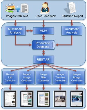
Thanks to the availability of mobile devices, emergency responders, supporting agencies and even private citizens can capture imagery of disaster events as they unfold. Once the crisis is contained, however, it's a daunting task for emergency managers to collect, organize and integrate disaster event data from multiple sources into incidence command systems where situation reports, incidence action plans, etc. are being held. Therefore, Dr. Chen's group has developed a semi-autonomous system, the Multimedia-Aided Disaster Information Integration System (MADIS), that uses advanced data integration and visual analysis techniques to associate temporal, spatial and other textual features of a disaster event situation report with event images and related text annotations.
The system is developed on Apple's mobile operating system (iOS) and runs on iPad tablets, and it is evaluated by domain experts from the local emergency management department. By interacting with the Miami-Dade Emergency Management (MDEM) personnel through evaluation and exercise activities, the system is constantly being updated by improving user interface experience and back-end support techniques. Feedback from our collaborative partners at MDEM and the potential users suggests that our system will be very useful for emergency managers to gain insight of the situation at the actual disaster scene and to respond swiftly. It is also encouraged to further develop the system into an operational pilot and promote the commercialization of the system for benefiting the whole Emergency Management community.
The system, developed as part of the project A Data Mining Framework for Enhancing Emergency Response Situation Reports with Multi-Agency, Multi-Partner, Multimedia Data, received funding from the Visual Analytics for Command, Control, and Interoperability Environments (VACCINE), the Department of Homeland Security's (DHS) Center of Excellence in Visual and Data Analytics, which was established in July of 2009.
For a demo of the project, play the video below.
Multimedia-Aided Disaster Information Integration System Demo
Business Continuity Information Network
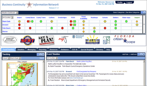
Dr. Chen's Business Continuity Information Network (BCIN) project is the first web-based Public-Private Partnership tool that helps the County Business Recovery Program communicate, share information, and collaborate on disaster events with the private sector.
By tracking the status of critical services over multiple counties, the BCIN helps businesses to better assess the impact of a disaster on the community and find resources to recover faster after a disaster. Additionally, it provides a gathering place for businesses to report on the available resources (products/services) they can provide, and helps county partners collect damage report data from county and company sources in order to understand the amount of damage in the business community immediately after a disaster event.
The role of the BCIN in the success of businesses is invaluable. Studies show that about 40% of the companies that closed for three or more days as a result of a hurricane failed within 36 months. If the BCIN helped 5% of the companies in South Florida to speed up their hurricane recovery by one week, it would prevent $220 million of non-property economic losses that would result from that week's closure.
Many businesses have already joined the Network. Some of the participating businesses are listed below:
- Florida International University
- American Airlines
- Aon Corporation
- AT&T
- Bank of America
- Baptist Health South Florida
- Becker & Poliakoff
- Carnival Cruise Lines
- Caterpillar
- ClearChannel Communications
- Crowley
- Exeter Architectural Products
- Florida Public Health Institute
- Florida Power and Light
- Greyhound Lines
- IBM
- Home Depot
- Hurricane Protection Industries
- Insurance Information Institute
- City Bank
- Beckman Coulter
- Greater Miami Convention & Visitor Bureau
- U.S. Century Bank
- Miami River Marine Group
- Greater Miami Chamber of Commerce
- Macy's Florida
- Miami Christian School
- Miami Dade College
- Miami International Airport
- Office Depot
- Publix Supermarkets
- Ryder Systems
- T-Mobile
- Target Stores
- Terremark
- Trane
- United States Postal Service
- UPS
- URS Corporation
- Visa
- Wal-Mart
- Wachovia Bank
- WFOR-CBS-4
- Winn-Dixie
- ABN AMRO
- American National Bank
- BAC Florida Bank
- Banco Popular
- Bank First
- Bank United
- City National Bank of Florida
- Commerce Bank, N.A.
- Executive National Bank
- Fidelity Federal Bank & Trust
- Intercredit Bank, N.A.
- International Bank of Miami, N.A.
- Mellon
- Mesirow Financial
- Northern Trust, N.A.
- Ocean Bank
- Regent Bank
- Sun American Bank
- Third Federal Savings
- Tropical Financial Credit Union
- Total Bank
- Transatlantic Bank
- Union Credit Bank
Since its release, the BCIN has been actively used in many community activities, some of which are listed below:
Hurricane exercise by using BCIN
-
2008
- Joint county exercises in March and May with partners
- Activated in Miami-Dade for Fay, Gustav, and Ike
-
2009
- Miami-Dade EM Business Recovery Desk
- Florida Statewide Hurricane Suitor Training Exercise
- UASI Operation Cassandra
- Miami-Dade EM Business Recovery Program Training
-
2010
- Private-Public Partnership in Palm Beach County
- Statewide Hurricane Exercise
- Expanded company exercise
- Focus on mobile platform
-
2011
- Florida Statewide Hurricane Griffin Exercise, Palm Beach County Emergency Management BCIN training and Exercise for the Business & Industry Desk Operations
- South Florida Disaster Management Symposium -- Miami-Dade, Browad, Palm Beach and Monroe County Organized by The South Florida Business Resiliency Consortium (SFBRC), SFBRC support BCIN as its information tool.
-
2013-2014
- Steve Detwiler was hired as the new business recovery manager at Miami Dade Emergency Management after almost two years of the position being vacant.
- The Business Recovery Program meet in 2013 to discuss activities leading into the 2014 hurricane season.
- A table top exercise which will involve BCIN is being planned either to coincide with the 2014 Hurricane Exercise or as an independent activity.
- BCIN training will occur with MDEM at the end of March 2014.
Dr. Chen has received multiple recognitions as his role has been critical for the success of the BCIN.
The development and implementation of the Business Continuity Information Network (BCIN) has provided the [Miami-Dade County's Business Recovery] program with a key tool necessary to carry out many of its critical functions including real-time data collection and gathering. BCIN is quickly becoming a nationally recognized information sharing tool for use by public-private collaborative programs ... FIU's contribution to the success of Miami-Dade County's Business Recovery Program is truly immeasurable. (Read recognition letter).
Part of a recognized Public-Private Partnership model by the FEMA Private Sector Office is available here.
New U.S.-Japan collaborations bring Big Data approaches to disaster response - NSF Press release 15-029 is available here. United States Senator Bill Nelson's recognition letter to project PI, Dr. Tao Li, is available here. Dr. Chen is the Co-PI of this project.
Click here to visit the Business Continuity Information Network's public service.
Coordinated Damage Assessment Application
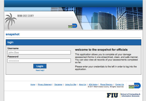
Dr. Chen's work on the Coordinated Damage Assessment Application (CDAA) is a reinterpretation of Miami-Dade County's SnapShot Damage Assessment Application.
The CDAA has been made available to the residents of Miami-Dade County, and has assisted in providing accurate situational awareness regarding the impact of a disaster as well as has helped emergency responders plan an appropriate response and recovery.
The CDAA is composed of two components: a public page and a private administration web application, both of which were powered by an application called Snapshot, which was officially used by the Miami-Dade Department of Emergency Management (DEM).
The CDAA is implemented with shared codebase to eliminate as much platform-specific code as possible, modularized code for organized and easily visualized application structure, and lightweight frameworks to abstract several developmental processes. It provides support for assessing either online or offline via PCs, laptops, tablets, and smartphones, and provides an aggregated view of the impact of the disaster.
The goals of this application are to leverage on the community's altruism, provide the community a role and leave them situationally aware, streamline impact assessments, rapidly gather disaster impact information, and efficiently plan for a response and recovery.
From the community's point of view, the CDAA's main roles are to simplify the assessment process for the affected properties and to provide feasible channels for having assessments. On the other hand, the CDAA is implemented for government officials to quickly update the assessment process and to support the ability to easily view and utilize aggregated impact results.
TRECVID Disaster Scene Description and Indexing (DSDI) Competition
TRECVID (TREC Video Retrieval Evaluation) is one of the most famous international video retrieval competitions, conducted by the National Institute of Standards and Technology (NIST), and has held a total of 15 competitions taking place annually since the year 2003.
Disaster Scene Description and Indexing (DSDIi) is a competition in TRECVID, a
workshop organized by the National Institute of Standards and Technology
(NIST).
Our team won first place on the TRECVID2020 - Disaster Scene Description
and Indexing (DSDI) track "O" runs. We were able to leverage our comprehensive
knowledge and previous work in the disaster data management and our past
experiences competing in other of TRECVID's tracks. Among a total of
four prioritized submitted runs following different relevancy sorting
techniques, three of our run submissions ranked the top 3 of all the
submissions.
We also won the first place on the TRECVID2021 - Disaster Scene Description
and Indexing (DSDI) track (regardless of training datasets utilized).
The DSDI track aims to develop new capabilities to label video clips
with disaster-related features/labels. Jeffrey Liu and Andrew Weinert
from MIT Lincoln Lab, are some of the main coordinators of this task.
DSDI is supported by LADI (Low Altitude Disaster Imagery), a training
dataset of various natural disasters images collected by the Civil Air
Patrol. The testing dataset is composed of 5 hours of video footage
segmented into small video clips of about a maximum of 60 sec each. The
challenge is a multi-label classification into 32 classes (including
debris, flooding, building, landslide, aircraft, etc.). Once a class has
been identified in one video or several videos, our goal is to organize
the shots in order of relevancy.
This research direction has a lot of potential in the development of
tools and technologies that can improve situational awareness during a
disaster event and ensure public safety.
In the Media
- FIU Engineering and Computing News - 2014
- FIU Engineering and Computing News - 2011
- Miami Herald - August 13, 2008
- South Florida Business Journal - December 23-29, 2005
Back to Top